🟡 Waterfall Way is closed but Bello isn't
Including: Where high levels of microplastics have been found on the MNC, why blue dragons washed ashore, how a local koala inspired a Cresso's newest mural and Bellingen businesses impacted by confusion over landslip.
Brad Esposito
March 18, 2026
⏱️ The 104th edition of our newsletter is a seven-minute read.
✋ Hey, it's Ellie – your Mid North Coaster reporter.
📢 Today’s call out: I would love to chat with people who;
Had their homes deemed uninhabitable after the May floods last year
Applied for the Home Repair Grant of up to $25k (whether the funding has been received or not)
If this is you, reply to this email and we’ll make a time to talk.

In todays newsletter we’re looking at:
A report published on Monday that looked at microplastic levels in coastal waterways across the state. Two creeks on the MNC were included in the top 10 most contaminated.
What’s happening off the Mid North Coast: an expert talks about why blue dragons were washed ashore at South West Rocks and the possible link to the mass moon pipi death at Diamond Head a week earlier.
How a local koala joey inspired Crescent Head's newest mural and the message behind the art.
Business owners want you to know that while Waterfall Way is closed due to a landslip, Dorrigo and Bellingen are open for business.
🍌 Before we dive in, incase you want to be a part of a world record attempt of the largest banana formation made by people…

🗓️ ONE FOR THE CALENDAR
On April 11, hundreds of people are set to gather at Jetty Beach in Coffs Harbour to attempt a world record for the largest banana formation made by humans to celebration the region’s heritage.
What: World record attempt of the largest banana formation made by people
Where: Jetty Beach, Coffs Harbour
When: Saturday 11 April, from 8am with the formation happening at 9.30am
Why: According to the City of Coffs Harbour, the world record attempt forms part of a broader community effort to support Coffs Harbour in the NSW Top Tourism Town Awards, encouraging people to vote for the destination and celebrate the region’s unique mix of natural beauty, adventure, and family-friendly experiences.
Council says it also plays a role in the This is MyCoffs grassroots community campaign, which aims to drive advocacy for Coffs Harbour through the voice of locals, building pride and love for the place they call home.

TWO TOP STORIES
🟡 Most contaminated coastal waterways: a top 10 ranking the Mid North Coast didn't want

It’s not unusual to see the Mid North Coast included in top 10 lists – mostly for its beautiful beaches and bush walks.
But according to new research from the NSW Government, the region has made the cut for something far less impressive: hosting some of the most contaminated coastal waterways in the state.
What happened: On Monday, an Australian-first microplastic report revealed the state’s most contaminated coastal waterways, including creeks in Coffs Harbour and South West Rocks.
The NSW Environment Protection Authority (EPA) and NSW Department of Climate Change, Energy, the Environment and Water (DCCEEW) worked together to deliver the assessment.
The report ranks coastal waterways by microplastic concentration in the top 15 centimetres of surface water, from most to least contaminated.
120 catchments were sampled from the Tweed to the Victorian border to identify the most affected sites and the types of microplastics present.
More than 31,000 particles were identified, including foam packaging and plastic pellets.
NSW EPA Chief Executive Tony Chappel said microplastics were detected in every waterway sampled.
Local impact: Coffs Creek in Coffs Harbour ranked number six in the state for most contaminated coastal waterways with South West Rocks Creek (locally known as Back Creek) just behind it, taking spot seven.
Both Coffs Creek and South West Rocks Creek were found to have very high levels of microplastics.

Credit: NSW Government

Credit: NSW Government
All other waterways in the top 10 most contaminated waterways are found in Sydney, including Parramatta River at number nine.
In contrast, Myall Lake in the MidCoast LGA south of Forster, is one of the least contaminated across the state.
Why it matters: Chappel said the report’s findings demonstrate the widespread nature of plastic contamination across urban, regional, and remote catchments – and will shape the next wave of action.
“Microplastics are one of the fastest-emerging threats to marine life and our environment, often washed from land into rivers and then into the ocean through stormwater drains,” Chappel said in a statement.
“We’ll use this groundbreaking data to develop models of sources and pathways to better target preventable pollution, work with water managers on local solutions and strengthen policies that keep microplastics out of our ecosystems.
🟡 Bellingen business owners want you to know the town is open

Bellingen business owners say a landslip, a closed road and some confusing signs have led to local businesses struggling through an already quiet period, as tourists and others on the Mid North Coast give the township the miss.
What happened: In January, a 250-tonne landslip closed Waterfall Way / B78 between Horseshoe Road and Boggy Creek Road – about 18-kilometres west of the highway exit and about six kilometres west of Bellingen’s township.
The signs read: “Waterfall Way Closed”.
Waterfall Way/B78 is the highway exit taken to get to Bellingen
While the major landslip and road closure continues to disrupt inland residents and the industries that rely heavily on the arterial route, it has not impacted access to Bellingen’s CBD.
Despite this, the misleading messaging has seen local businesses experience a noticeable drop in visitation.

The landslip closed Waterfall Way west of Bellingen. Credit: Live Traffic NSW
Business suffers: Alex Caminer, co-owner of Alternatives Bookshop on Bellingen’s Hyde Street, is also on the board of the local Chamber of Commerce.
He said Bellingen businesses have felt the effects of January’s landslip, especially as the summer peak season comes to an end.
Quiet months: Caminer said locals “trade off the tourist business” and while this time of year typically slows down for retail, hospitality and tourism, the billboards haven’t helped.
“In February and March, everyone's getting back in rhythm and a little hungover from a big Christmas expenditure,” Caminer told the Mid North Coaster.
“The billboards on the highway initially said something like ‘Waterfall Way closed’ and it was a bit ambiguous where [the closure] was.”
Caminer said the miscommunication has “doubled the pressure” on businesses to stay afloat coming into the cooler months.
“Some of [the businesses on the street] are just basically trying to stay open to get through this period rather than actually make any money. Just trying to keep the business alive,” Caminer said.
Concern to outlast: Expecting the road won’t be completely reopened for another few months, Caminer is concerned for his fellow business owners.
“I wouldn't be surprised if we see, by the end of this period… that we'll see a few businesses turn over in town, which will be really sad,” Caminer said.
While the bookshop is “doing fine”, Caminer acknowledges other businesses are struggling. He wants to see the stretch of road – notorious for landslips – upgraded to better withstand future extreme weather events.
“We get a landslip every now and then. It was just waiting for one that was big enough, that was actually going to put the road out of action for a significant time,” Caminer said.
The landslip in January was the fourth closure of Waterfall Way in the past 12 months due to a landslip caused by heavy rainfall.
Repair, when? On February 18, the NSW Government committed to restoring controlled one-lane access to Waterfall Way within six weeks, following an engineering assessment of the landslip.
Alongside interim traffic arrangement, the government said engineers would continue planning for a permanent solution involving stabilisation design and risk mitigation work at the site.
Currently, Waterfall Way remains closed between Thora and Boggy Creek. Those travelling to Dorrigo can follow detour signage.
In the meantime, the government has announced support for residents, businesses, primary producers and councils to help with recovery – including low-interest loans of up to $130,000 for small businesses and primary producers.
An important link: As a resident and business owner, Caminer wants to see Waterfall Way acknowledged as an important arterial road with funds at the ready in a disaster event.
“It's very hard to ask for funds for preventative measures… but once [a landslip has] happened, it's almost too late and the cleanup is always more expensive than any preventative medicines or activities there,” Caminer said.
“It’s a major arterial road. The whole New England plateau – cows, logs, lorries – everything has to come down that Dorrigo mountain off the plateau to get to the coast. It’s been very difficult for businesses up there.”
“You can still get up to Dorrigo and beyond, but it adds a good 20 minutes or turns a 25-minute journey up the mountain into 45 minutes.”
In the meantime, Carminer is encouraging visitors to the area.
“It’s a nice time of year. It's a beautiful time of year. As the weather's just starting to cool off, but it's still warm, the swimming holes are more open.”

📹 VIDEO OF THE DAY
It’s not often you see a blue dragon on Mid North Coast beaches. The small sea slugs, otherwise known as a blue glaucus, immediately grab attention for their otherworldly aesthetic. But on Thursday, residents of South West Rocks would’ve been able to see dozens washed up at the beach, stagnant on the sand.
Experts say the unusual event is likely linked to above average ocean temperatures – a phenomenon that strongly influences weather patterns in Australia.
I spoke to Adrian Meder from the Australian Marine Conservation Society who told me about the marine creatures and explained what’s going on in our waters.
Watch the video below and read the article on our website here.


You can also watch the video on TikTok, YouTube or our Facebook page.

🐨 How a local koala joey inspired Crescent Head's newest mural

A once unremarkable toilet block on Baker Drive in Crescent Head has been transformed into a piece of art with a point: protecting koalas is a must.
What happened: Abai the koala was just a joey when she was struck by a vehicle while crossing Crescent Head Road in 2023.
She was successfully rehabilitated at the Port Macquarie Koala Hospital and released back into the wild in 2024. Now, her picture is painted as a mural near where she was hurt and then released once healthy.
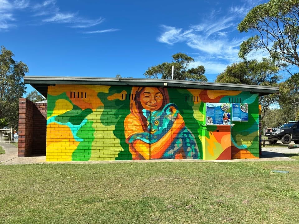
The mural: Patrick Indo, who goes by the name INDO, is the artist behind the mural. Koalas in the Macleay is a large-scale tribute to Abai and her endangered species.
Commissioned by Kempsey Shire Council and Port Macquarie Koala Hospital, the artist says his work is about the importance of conservation.
In 2022, koalas were listed as endangered in New South Wales, Queensland and the Australian Capital Territory.
The 2020 parliamentary inquiry into NSW koala populations and habitat concluded that, without action, koalas in NSW could be extinct by 2050 due to increasing and cumulative threats from habitat loss, fragmentation and climate change. Intense and more frequent heatwaves are causing drought and bushfires that directly impact koala populations across the east coast.
Indo says his mural urges residents and visitors to consider their role in ensuring the survival of koala populations in the area.

The message: The artist says the project blends art and education, and encourages responsibility.
“The message is clear: drive carefully, protect habitat and manage pets responsibly,” Indo said.
“In Crescent Head, a simple building now tells a vital story — one of resilience, community and the urgent need to ensure koalas remain part of the Macleay landscape for generations to come.”
Indo says the work also acknowledges the “deep cultural history” of the region.
“For the Dunghutti people, the koala — known as yarri — has long been part of Songlines and local identity,” Indo said. “By weaving this heritage into the composition, the mural connects past, present and future.”

I hope you enjoyed this edition! I’ll be back on Friday with another newsie.
In the meantime, make sure you’re following along on Instagram, TikTok, YouTube, Facebook and our website to keep up to date with local news throughout the week.
Thanks for reading,
👋 Ellie